

Paper Menu >>
Journal Menu >>
 Journal of Environmental Protection, 2011, 2, 1285-1294 doi :1 0.4236/ jep.2011. 210148 Published Online December 2011 (http://www.SciRP.org/journal/jep) Copyright © 2011 SciRes. JEP 1285 Characteristics of Large-Scale Harmful Algal Blooms (HABs) in the Yangtze River Estuary and the Adjacent East China Sea (ECS) from 2000 to 2010 Li Shen1*, Huiping Xu1, Xulin Guo2, Meng Li2 1State Key Laboratory of Marine Geology, Tongji University, Shanghai, China; 2Department of Geography and Planning, University of Saskatchewan, Saskatoon, Canada. E-mail: *[email protected] Received S eptember 9th, 2011; revised October 12th, 2011; accepted November 17th, 2011. ABSTRACT Harmful algal blooms (HABs) are a serious worldwide issue which has posed great risks on marine ecosystems and public health by directly releasing toxins or indirectly leading to anoxia in marine environment. In recent years HABs have caused huge economic losses in China, particularly in the Yangtze Estuary and the adjacent East China Sea (ECS). The present study investigated the spatial-temporal and species characteristics of large-scale HABs in this area using geographic information system (GIS) Kernel Density Estimation (KDE) spatial analysis, statistical methods and sa- tellite image interpretation. Results revealed that the Yangtze Estuary, Zhoushan island, Xiangshan bay and Jiushan island are the regions with highest frequency of large-scale HABs. HABs in the ECS reached a peak in terms of total number and area in 2003 to 2005 and occupied a high percentage (around 70% in area and 60% in occurrence) in the four Chinese coastal waters. The number of large-scale HABs (>1000 km2) in the Yangtze Estuary and the adjacent ECS declined after 2005 while that of HABs (>100 km2) declined after 2008. Large-scale HABs occurrences con- centrated in summer (May to July), and the averaged duration increased continually from the shortest time (1.3 days) in 2001 to the longest (10.9 days) in 2010 for each HAB. 17 causative species were found with Prorocentrum dentutam as the most frequent dominant species, followed by Skeletonema costatum, Karenia mikimotoi, and Chaetoceros curvisetus. Water discoloration observed in MODIS satellite true color images was well consistent with the corresponding HABs reported by State Oceanic Administration of China (SOA). Multiple factors involving eutrophication, physical dynamics, topography and deposition conditions contributed to the formation of frequent HABs in the ECS. Three strategies including establishing a synthesized system, improving the previous database and investigating multiple contributors were proposed for future HABs monitoring and management. Keywords: Harmful Algal Blooms (HABs), Yangtze Estuary, The East China Sea, Spatial and Temporal Characteristics, Causative Species, Remote Sensing 1. Introduction Harmful algal blooms (HABs), also known as “red tides”, have become a serious environmental issue which draws great attention in both governments and academic com- munities worldwide. Especially in recent years most coas- tal areas around the world are severely suffering from HABs of increasing frequency and expanding spatial ex- tent [1,2]. HAB phytoplankton species can cause damage to marine ecosystems as well as public health in two ways. One is to directly release toxins and the other is to induce hypoxia and anoxia of marine organisms by accumu- lating biomass [3,4]. HABs are considered as one of the biggest marine disasters due to the considerable environ- mental contamination and huge economic losses as a re- sult of mass morality of aquaculture [5,6]. China is a country with board coastal areas contributed by four marginal seas namely Bohai, Yello w Sea, the East China Sea (ECS) and the South China Sea, have been post great risk by HABs ever y year since the first d ocum ented HAB in 1933 [2,7]. According to previous investigation, the ECS, consisting of broad waters (the Yangtze Estuary,  Characteristi cs of Large-Scale Harmful Algal Blooms (HABs) in t he Yangtze River Estuary and th e Adjacent E ast 1286 China Sea (ECS) from 2000 to 2010 the coastal areas of Zhejiang and Fujian province), is the area most rigorously impacted by HABs among the four main coastal waters nationwide. In particular, the Yangt- ze River and the coast of Zhejiang Province are the hots- pots of frequent large-scale and intensive HABs in the ECS [7-9]. Economic developments facilitated by aqua- culture industries and coastal recreations of Shanghai (the number one metropolis in China) and Zhejiang Province (the most developed region in China) are threatened by annual HAB occurrences in the aforementioned areas. Worse still, Chen et al. [10] pointed out that those HABs in the ECS if last for more than 3 weeks might be trans- ported to the Japanese or Korean coast by Kuroshio to cause worldwide harm. Therefore, studying the HABs trends in t he EC S with reg ard s to the spat ial -te mpor al c ha- racteristics is of great significance for forecasting marine damage, protecting pu blic health as well as promoting eco- nomic development not only in China but also in other neighboring count ries. In the present study we analyzed the spatial and tem- poral variability of historical large-scale HAB events from 2000 to 2010 in the Yangtze Estuary and the adja- cent ECS water using GIS techniques and statistical me- thods. We also used MODIS satellite data to show the potentiality of obs ervi ng larg e- scale HA Bs in th e tru e com- posite imagery derived from basic remote sensing pro- cessing and interpretation. In addition, the contributing fac- tors for frequent HABs and potential strategies for mo- nitor ring such HABs are also discussed. 2. Materials and Methods 2.1. Study Area Our study area is the ECS specifically in the Yangtze River Estuary and the adjacent water (around 27˚ - 32˚N, 120˚ - 123˚E) shown in Figure 1. As a marginal sea, the ECS lying between the Asia Continent and the Pacific Ocean, has broad water with a variety of islands (Hua- niao shan, Ma’an, Shengsi, Zhoushan, Jiushan, Yushan, Dong ji, Dongtou and Nanlu). The complicated oceano- graphic characteristics in this region are contributed by the interaction of complex circulation systems, meteoro- logical conditions as well as geological topography. This area is also characterized by high entrophication and pri- mary productivity from various nutrition sources such as the runoff of the Yangtze River and the coastal subsur- face water [11]. This area with the largest fishery in Zhoushan and Shengsi islands plays an important role in the local and national economical growth but at the same time suffers from serious HABs every year. Locations of Figure 1. The study area and locations of historical frequent HABs (alphabetically marked). A. (the Yangtze Estuary), B. (Huaniao shan island), C. (Ma’an island), D. (Shengsi island), E. (Hangzhou bay), F. (Zhoushan island), G. (Xiangshan bay), . (Jiushan island), I. (Yushan island), J. (Yushan island), K. (Dongtou island), L. (Cangnan areas), and M. (Nanlu island). H Copyright © 2011 SciRes. JEP 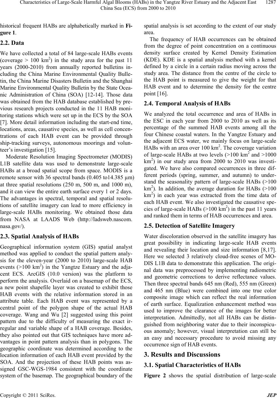 Characteristi cs of Large-Scale Harmful Algal Blooms (HABs) in t he Yangtze River Estuary and th e Adjacent E ast 1287 China Sea (ECS) from 2000 to 2010 historical frequent HABs are alphabetically marked in Fi- gure 1. 2.2. Data We have collected a total of 84 large-scale HABs events (coverage > 100 km2) in the study area for the past 11 years (2000-2010) from annually reported bulletins in- cluding the China Marine Environmental Quality Bulle- tin, the China Marine Disasters Bulletin and the Shanghai Marine Envir onmental Q ualit y Bulleti n by the St ate Ocea - nic Administration of China (SOA) [12-14]. Those data was obtained from the HAB database established by pre- vious research projects conducted in the 11 HAB moni- toring stations which were set up in the ECS by the SOA [7]. More detail information including the start-end time, locations, areas, causative species, as well as cell concen- trations of each HAB event can be provided through ship-tracking surveys, autonomous moorings and volun- teer’s investigation [15]. Moderate Resolution Imaging Spectrometer (MODIS) L1B satellite data was used to demonstrate large-scale HABs at a broad spatial scope from space. MODIS is a remote sensor with 36 spectral bands (0.405 to14.385 µm) at three spatial resolutions (250 m, 500 m, and 1000 m), and it can view the entire earth surface every 1 or 2 days. The advantages in spectral, temporal and spatial resolu- tions of satellite imagery can lead to more efficiency in large-scale HABs monitoring. We obtained those data from NASA at LAADS Web (http://ladsweb.nascom. nasa.gov/). 2.3. Spatial Analysis of HABs Geographical information system (GIS) spatial analyst method was applied to conduct the spatial pattern analy- sis for the eleven-year (2000 to 2010) large-scale HAB events (>100 km2) in the Yangtze Estuary and the adja- cent ECS. ArcGIS (10.0 version) was the platform to perform the analysis. Overlaid on a basemap of the ECS, a new point shapefile layer was created to exhibit those HAB events with the relative information stored in an attribute table. Each HAB event was represented by a central point of the polygon shape of the actual HAB coverage. Wang and Wu [2] suggested using this point pattern due to the difficulty of measuring the exact ir- regular and variable shape of a HAB coverage. Besides, they also pointed out that GIS techniques have more ad- vantages in point pattern analysis than in polygons. The geographic coordinate was determined according to the location information of each HAB event provided by the SOA. And the projection of these HAB points was as- signed GSC-WGS-1984 consistent with the coordinate system of the basemap. The geographical boundary of the spatial analysis is set according to the extent of our study area. The frequency of HAB occurrences can be obtained from the degree of point concentration on a continuous density surface created by Kernel Density Estimation (KDE). KDE is a spatial analysis method with a kernel defined by a circle in a certain radius moving across the study area. The distance from the centre of the circle to the HAB point is measured to give the weight for that HAB event and to determine the density for the centre point [16]. 2.4. Temporal Analysis of HABs We analyzed the total occurrence and area of HABs in the ESC in each year from 2000 to 2010 as well as its percentage of the summed HAB events among all the four Chinese coastal waters. In the Yangtze Estuary and the adjacent ECS water, we mainly focus on large-scale HABs with an area over 100 km2. T he co ve ra ge va r iatio n of large-scale HABs at two levels (>100 km2 and >1000 km2) in our study area from 2000 to 2010 was investi- gated. We have also compared occurrences in three dif- ferent periods (spring, summer, and autumn) to under- stand the seasonality pattern of large-scale HABs (>100 km2). In addition, the average duration for HABs (>100 km2) in each year was extracted from the time data of each HAB event. We also investigated the causative spe- cies of large-scale HABs (>100 km2) in the past 11 years and ranked them in terms of HAB occurrences and area. 2.5. Detection of Satellite Imagery Water discoloratio n observed in the satellite ima gery has great possibility in indicating large-scale HAB events and revealing their location and size information [8,17]. Here we selected 3 relatively cloud-free scenes of MO- DIS L1B data to demonstrate this application. The origi- nal data was preprocessed by implementing radiometric and geometric corrections to derive reflectance values. Then three spectral bands 645 nm (Red), 555 nm (Green) and 465 nm (Blue) were combined into one true color composite image which can reflect the real information of earth surface. Equalization enhancement method was used to improve the clearance of the images for better interpretation. Admittedly, not all HABs can be distin- guished from neighboring water due to their inconspicu- ous anomaly; however, visual interpretation can still be an easy and necessary procedure to avoid missing any occurrence sign of HAB events. 3. Results and Discussions 3.1. Spatial Characteristics of HABs Figure 2 shows the spatial distribution of large-scale Copyright © 2011 SciRes. JEP  Characteristi cs of Large-Scale Harmful Algal Blooms (HABs) in t he Yangtze River Estuary and th e Adjacent E ast 1288 China Sea (ECS) from 2000 to 2010 Figure 2. Locations of large-scale HABs (>100 km2) in periods from 2000 to 2010 in the Yangtze Estuary and the adjacent ECS water. Each point represents one HAB event. HABs (100 km2) in the study area from 2000 to 2010. In general, they widely dispersed in all coastal waters of Shanghai municipality as well as Zhejiang province, and clustered in some certain areas. The KDE result (Figure 3) showed that the Yangtze Estuary (A), Zhoushan island (F), Xiangshan bay (G) and Jiushan island (H) are the regions with highest frequenc y of large-scale HABs, and these regions are also hotspots of HABs at normal scales in the ECS along isobaths of 30 - 60 m in the ECS [2,7]. High frequency of large-scale HABs appeared in around 20 km scope outside of the HAB hotspots, and areas of medium frequency were observed in regions of another 20 km away. Other areas have comparatively low possi- bility to induce large-scale HABs 3.2. Temporal Characteristics of HABs Both occurrences and areas of HABs in the ECS were found to be sharply increasing in the early years of the past 11 years from 2000 to 2010 until a peak appears (2003 for occurrences and 2005 for areas), and then show- ed a decreasing pattern in the rest years (Figure 4(a)). Particularly in 2004 and 2006, HAB occurrences and areas appeared contrast variation characterist ics (lo w HAB occurrence with high bloom area), indicating that the scale of these HABs are large enough to cover a huge area in despite of a small number of occurrences. After 2006, the scale of HABs in the ECS became smaller which can be found in Figure 4(a). Figure 4(b) shows that HABs in the ECS accounted for a high percentage of the total HABs in the all four Chinese coastal water in terms of occurrence number and areas, especially in 2002 (64.6% for occurrence and 88.7% for area), 2003 (72.3% for occurrence and 89.3% for area) and 2008 (69.6% for occurrence and 88% for area). In the Yangtze Estuary and the adjacent ECS water, number of HABs with an area over 1000 km2 has an in- creasing trend from 2000 to 2005, but declined in the next ha lf of the se 1 1 years ( blue hi sto gra ms in Figure 5). In 2005 alone, the occurrences of such large-scale HABs were found to reach 8. Red histograms in Figure 5 illus- trated occurrences of HABs over 100 km2 kept rising until 2008 with a peak of 16, and in the last two years decreased but still maintained at a higher lever (over 9). We also investigated the seasonality and duration of large-scale HABs (>100 km2) in this area. The hotspot season of HABs was observed in Figure 6 to fall in sum- mer (May-July) with an annually averaged occurrence of 6.27, and a total number of 66 responsible for 78.4% of the documented 88 HABs from 2000 to 2010. Prior to 2007, only one large-scale HAB (>100 km2) event was reported in autumn (August to October) but later than 007 12 HABs (>100 km2) were recorded in autumn. In 2 Copyright © 2011 SciRes. JEP 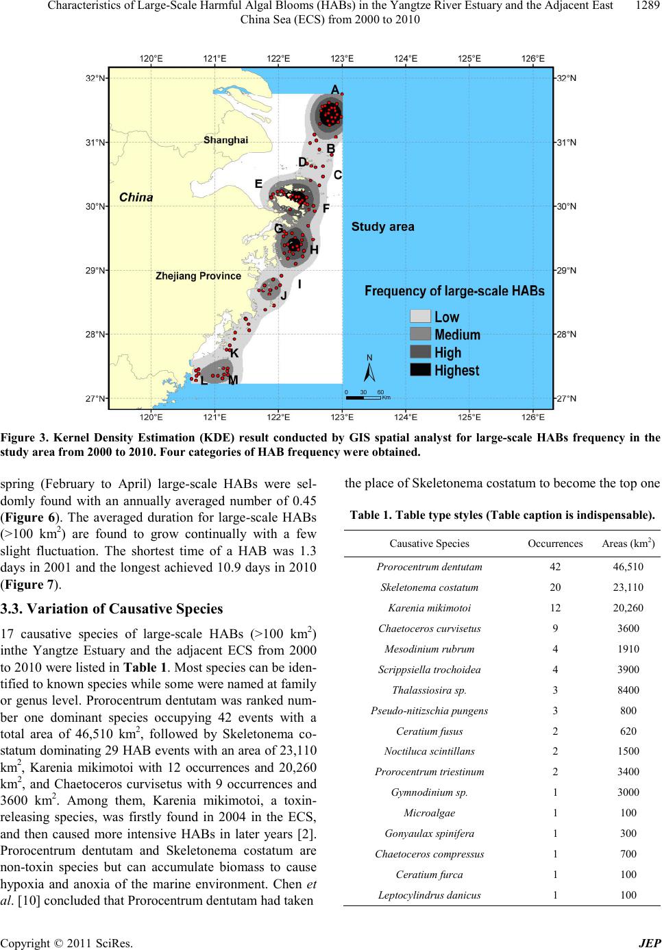 Characteristi cs of Large-Scale Harmful Algal Blooms (HABs) in t he Yangtze River Estuary and th e Adjacent E ast 1289 China Sea (ECS) from 2000 to 2010 Figure 3. Kernel Density Estimation (KDE) result conducted by GIS spatial analyst for large-scale HABs frequency in the study area from 2000 to 2010. Four categories of HAB frequency were obtained. spring (February to April) large-scale HABs were sel- domly found with an annually averaged number of 0.45 (Figure 6). The averaged duration for large-scale HABs (>100 km2) are found to grow continually with a few slight fluctuation. The shortest time of a HAB was 1.3 days in 2001 and the longest achieved 10.9 days in 2010 (Figure 7). 3.3. Variation of Causative Species 17 causative species of large-scale HABs (>100 km2) inthe Yangtze Estuary and the adjacent ECS from 2000 to 2010 were listed in Tab le 1 . Most species can be iden- tified to known species while so me were named at family or genus level. Prorocentrum dentutam was ranked num- ber one dominant species occupying 42 events with a total area of 46,510 km2, followed by Skeletonema co- statum dominating 29 HAB events with an area of 23,110 km2, Karenia mikimotoi with 12 occurrences and 20,260 km2, and Chaetoceros curvisetus with 9 occurrences and 3600 km2. Among them, Karenia mikimotoi, a toxin- releasing species, was firstly found in 2004 in the ECS, and then caused more intensive HABs in later years [2]. Prorocentrum dentutam and Skeletonema costatum are non-toxin species but can accumulate biomass to cause hypoxia and anoxia of the marine environment. Chen et al. [10] concluded that Prorocentrum dentutam had taken the place of Skeletonema costatum to become the top one Table 1. T a ble t ype st yles (Table caption is i ndispens able). Cau sative Species Occurrences Areas (km2) Prorocentrum dentutam 42 46,510 Skele t on ema cost at um 20 23,110 Kare nia mikimo toi 12 20,260 Chae to c eros cur visetus 9 3600 Mesodinium rubrum 4 1910 Scrippsiella trochoidea 4 3900 Thalassiosira sp. 3 8400 Pseudo-nitizschia pungens 3 800 Ceratium fusus 2 620 Noctiluca sc intillans 2 1500 Prorocentrum triestinum 2 3400 Gymnodinium sp. 1 3000 Microalgae 1 100 Gonyaulax spinife ra 1 300 Chaetoceros compress us 1 700 Ceratium furca 1 100 Leptocyli ndrus dan icus 1 100 Copyright © 2011 SciRes. JEP  Characteristi cs of Large-Scale Harmful Algal Blooms (HABs) in t he Yangtze River Estuary and th e Adjacent E ast 1290 China Sea (ECS) from 2000 to 2010 (a) (b) Figure 4. HAB occurrences and areas in the ECS from 2000 to 2010. (a) Total number and area of annual HABs. (b) Per- centage of HAB s (ECS) of the all four Chinese co astal areas. HAB causative species in the ECS. One Prorocentrum dentutam HAB was observe d covering an area over 10,000 km2 in 2004. Ot her phytoplankton species seldomly ca used large-scale HABs by itself but in a seconddary role coo- per ating w ith th e dom inan t speci es . 3.4. Observation of HABs in Satellite MODIS true color composite images (Figure 8(a-c)) showed the water discoloration of two large-scale HABs in May to June, 2005. According to the recorded HAB in- formation provided by the SOA, a HAB with the cov- erage of 7000 km2 caused by Prorocentrum dentutam and Karenia mikimotoi occurred in the Yangtze Estuary from May 24, 2005 to June 1, 2005. In the same year, another large-scale HAB over 400 km2 caused by Skeletonema costatum was also found in the Yangtze Estuary with cell concentration of 4.2 × 10⁷/L from June 15, to June 21 [12-14]. The areas circled in a highlighted red box were the anomalies caused by the accumulated biomass of the HAB phytoplankton, in notable contrast with the neigh- boring waters. The locations of these discolored areas were confirmed by the distribution information of the corresponding HABs reported by the SOA. Those ab- normal regions are well consistent with the areas of fre- Copyright © 2011 SciRes. JEP  Characteristi cs of Large-Scale Harmful Algal Blooms (HABs) in t he Yangtze River Estuary and th e Adjacent E ast 1291 China Sea (ECS) from 2000 to 2010 Figure 5. Occurrences of large-scale HABs at two levels (> 100 km2 and >1000 km2) in the Yangtze Estuary and the ad- jacent ECS from 2000 to 2010. Figure 6. Seasonal occurrences of large-scale HABs (>100 km2) in th e Yangtze Estua r y and t he ad jac en t ECS from 2000 to 2010. Figure 7. Annually averaged duration of each large-scale HAB (>100 km2) event in the Yangtze Estuary and the ad- jacent ECS from 2000 to 2010. quent HABs in the ECS. 3.5. Contributing Factors for Large-Scale HABs Multiple contributing factors can lead to the formation of large-scale HABs in the study area. The severe eutrophi- (a) (b) (c) Figure 8. Water discoloration of HABs in MODIS true co- lor composite images. (a). MODIS true color i mage on May 25, 2005; (b). MODIS true color image on May 29, 2005; (c). MODIS true color image on June 16, 2005. cation along with high productivity in the ECS was thought to be the main inducement of frequent HABs by Copyright © 2011 SciRes. JEP  Characteristi cs of Large-Scale Harmful Algal Blooms (HABs) in t he Yangtze River Estuary and th e Adjacent E ast 1292 China Sea (ECS) from 2000 to 2010 influencing the congregation rate of phytoplankton spe- cies [18]. An extremely high cell concentration of phyto- plankton species resulted from exponential propagation can indicate a corresponding HAB [19]. The cell concen- tration peak in the ECS normally appears in June to Sep- tember such as Skeletonema costatum with average abun- dance of 7.93 × 10⁴ cell L–1 [20]. Increasing amounts of nutrie nts fr om t he Ya ngtze Ri ver r unoff went to the EC S every year, which provided necessary phosphorus and nitrogen concentration to flourish HAB species [21]. An- thropogenic effects such as overuse of fertilizers, in- dus- trial sewage and excess fishery in the coastal cities (e.g. Shanghai, Hangzhou and Ningbo) also play an impor- tant role in leading to the eutrophication condition [20,22]. Besides, our study area is impacted by complicated oceanographic processes and dynamics involving Taiwan Warm Current (16˚C to 29.5˚C), the Yangtze Diluted Water (>22˚C), the Yellow Sea Cold Current, the Ku- roshio Current and the Zhejiang Coastal Current, which can bring tremendous amounts of nutrients from different sources. Particularly the Yangtze Diluted Water serves as the main nutrient source because of the high suspended sediment deposition in the area of west 122.5˚E. A con- vergence zone characterized by the temperature and sa- linity fonts is formed also around 122.5˚E where the Tai- wan Warm Current meets with the nutrient-rich Yangtze River, favorable for the formation of HABs. The north- ward advection of the Taiwan Warm Current also plays a signi ficant role to transp ort nutrien ts from a remote so urce in Taiwan Strait. Meanwhil e, the Zhejiang Coastal C u r r e nt can bring nutrients up to the HAB region from the sub- surface layer in the upwelling zones [7,8,11,23,24]. Thirdly, our study area, on the northwest continental shelf of the ECS, is characterized by special topography and sediment deposition favorable for the HAB occur- rences. The west slope of 6 × 10⁻³ in the de ep tr ough has positive effects on the formation of upwelling currents [25,26]. The large-scale HABs locate in the high-velocity deposition zone in which nutrients at the bottom sedi- ments can facilitate the implantation of algal cyst hy- popus by the resuspending process particularly in sum- mer [26,27]. That can explain why summer is the peak period for frequent large-scale HABs [28]. 3.6. Strategies for HABs Monitoring and Management For future monitoring and management of large-scale HABs, there are some points that should be taken into consideration. First, it is necessary to establish a synthe- sized HAB system in the areas of frequent large-scale HABs by combining multiple data sources including sa- tellite remote sensing, aerial photography, in situ ship- tracking surveys, autonomous moorings, and laboratory analysis into a whole database. Particularly remote sens- ing techniques are promising to conduct comprehensive HAB research at different spatial and temporal scales. Multiple satellite imagery can be fully utilized to extract water classification and biophysical parameters distri- bution for monitoring and forecasting HABs. Second, it is of great help to enhance the previous HAB database by investigating the spatial-temporal pattern of historical large-scale HABs caused by different phytoplankton species in a long period. In addition, multiple contri- buting factors in biochemistry, physical dynamics, geo- logy and meteorology should be comprehensively studied for better understanding the true mechanism the large-scale HABs . 4. Conclusions The results in the present study show that from 2000 to 2010 the Yangtze Estuary, Zhoushan island, Xiangshan bay and Jiushan island are the regions with highest fre- quency of large-scale HAB. HABs in the ECS reached a peak in terms of total number and total area in 2003 to 2005 and occupied a high percentage of HABs in the four Chinese coastal waters. Number of large-scale HABs (> 1000 km2) in the Yangtze Estuary and the adjacent ECS declined after 2005 while that of HABs (>100 km2) declined after 2008. Large-scale HABs occurrences con- centrated in summer (May to July) accounted for 78.4% of the total HABs in the past 11 years. The averaged duration for HABs (>100 km2) increased continually with the shortest time (1.3) days in 2001 and the longest (10.9 days) in 2010. In the study area 17 causative spe- cies were found for those large-scale HABs (>100 km2) with Prorocentrum dentutam as the most frequent domi- nant species, followed by Skeletonema costatum, Kare- nia mikimotoi, and Chaetoceros curvisetus from 2000 to 2010. Water discoloration found in satellite true color composite imagery was well consistent with distributions of the corresponding HABs in 2005 reported by SOA, falli n g i n the r e gions of fr e quent H AB s d er i ved fr o m GI S spatial analyst. Multiple factors involving eutrophication, physical dynamics, topography and deposition conditions can explain the formation of such large-scale HABs in the ECS. Three strategies including establishing a syn- thesized system, improving the previous database and in- vestting multiple contributors were proposed for future HABs monitoring and management. 5. Acknowledgements This research was supported by the program of Key La- boratory of Marine Geology in Tongji University under number MG20080104 and Foundation of Shanghai Science and Technology Committee on Key Projects und er nu mb e r Copyright © 2011 SciRes. JEP  Characteristi cs of Large-Scale Harmful Algal Blooms (HABs) in t he Yangtze River Estuary and th e Adjacent E ast 1293 China Sea (ECS) from 2000 to 2010 09DZ1201000. The authors also would like to acknow- ledge the reviewers for their comments and suggestions on this manuscript. REFERENCES [1] D. M. Anderson, “Turning Back the Harmful Red Tide,” Nature, Vol. 388, 1997, pp. 513-514. doi:10.1038/41415 [2] J. H. Wang and J. Y. Wu, “Occurrence and Potential Risks of Harmful Algal Blooms in the East China Sea,” Science of the Tota l Environ ment, Vol. 407, No. 13, 2009, pp. 4012 -4021. doi:10.1016/j.scitotenv.2009.02.040 [3] D. M. Anderson, P. M. Glibert and J. M. Burkholder, “Harmful Algal Blooms and Eutrophication: Nutrient Sour- ces, Composition, and Consequences,” Estuaries, Vol. 25, No. 4b, 2002, pp. 704- 7 26. doi:10.1007/BF02804901 [4] D. M. Anderson, “Approaches to Monitoring, Control and Management of Harmful Algal Blooms (HABs),” Ocean and Coastal Management, Vol. 52, No. 7, 2009 , pp. 342- 347. doi :10.1016 /j.ocecoaman.2009.04.006 [5] D. M. Anderson, “Toxic Algal Blooms and Red Tides: A Global Perspective,” In: T. Okaichi, D. M. Anderson and T. Nemoto, Eds., Red Tides: Biology Environmental Sci- ence and Toxicology, Elsevier, New York, 1989, pp. 11- 16. [6] D. L. Tang, D. R. Kester, I-H. Ni, et al., “In Situ and satEllite Observations of a Harmful Algal Bloom and Wa- ter Condition at the Pearl River Estuary in Late Autumn 1998,” Harmful Algae, Vol. 2, No. 2, 2003, pp. 89-99. doi:10.1016/S1568-9883(03)00021-0 [7] D. L. Tang, B. P. Di, G. F. Wei, et al ., “Spatial, Seasonal and Species Variations of Harmful Algal Blooms in the South Yellow Sea and East China Sea,” Hydrobiologia, Vol. 568, No. 1, 2006, pp. 245-253. do i:10.1007/s10750-006-0108-1 [8] L. Shen, H. P. Xu and P. Wu, “Marine Environmental Characteristics of the Yangtze River Estuary and the Ad- jacent East China Sea d uring Algal Blo oms,” Marine E n- vironmental Science, Vol. 29, 2010, pp. 631-635. [9] G. F. Wei, D. L. Tang, and S. F. Wang, “Distribution of Chlorophyll and Harmful Algal Blooms (HABs): A Re- view on Space Based Studies in the Coastal Environments of Chinese Marginal Seas,” Advances in Space Research, Vol. 41, No. 1, 2008, pp. 12-19. doi:10.1016/j.asr.2007.01.037 [10] C. S. Chen, J. R. Zhu, R. C. Beardsley, et al., “Physical- Biological Sources for Dense Algal Blooms near the Chang- Jian g River,” Geophysical Research Letters, Vol. 30, No. 10, 2003, pp. 22-25. doi:10.1029/2002GL016391 [11] J. M. Zhou, Z. L. Shen and R. C. Yu, “Responses of a Coastal Phytoplankton Community to Increased Nutrient Input from the Ch angjiang (Yangtze) River,” Continental Shelf Research, Vol. 28, No. 12, 2008, pp. 1483-1489. do i:10.1016/ j.csr.2007.02.009 [12] SOA (the State Oceanic Administration of China), “The China Marine Environmental Quality Bulletin,” 2000-2010a. http://www.soa.gov.cn/soa/hygb/hjgb/A010901index_1.ht m [13] SOA (The State Oceanic Administration of China), “The China Marine Disasters Bulletin,” 2000-2010b. http://www.soa.gov.cn/soa/hygb/zhgb/A010902index_1.h tm [14] SOA (The State Oceanic Administration of China), “The Shanghai Marine Environmental Quality Bulletin,” 2000- 2010c. http://www.eastsea.gov.cn/Module/more.aspx?categoryid =70 [15] SOA (the State Oceanic Administration of China), “Tech- nical Specification of Algal Harmful Blooms,” HY/T069- 2005, 2005 [16] A. C. Gatrell, T. C. Bailey, P. J. Diggle, et al., “Spatial Points Pattern Analysis and Its Application Geographical Epidemiolog y,” Transactions of the Institute of British Geo- graphers, Vol. 21, No. 1, 1996, pp. 256-274. doi:10.2307/622936 [17] R. P. Stumpf and M. C. Tomlinson, “Remote Sensing of Harmful Algal Blooms,” In: R. L. Miller, C. E. Del Castillo and B. A. McKee, Eds., Remote Sensing of Coastal Aquatic Environments, Springer, AH Dordrecht, 2005, pp. 277-296. doi:10.1007/978-1-4020-3100-7_12 [18] I. V. Telesh, “Plankton of the Baltic Estuarine Ecosys- tems with Emphasis on Neva Estuary: A Review of Pre- sent Knowledge and Research Perspectives,” Marine Po- llution Bulletin, Vol . 49, No. 2, 20 04, pp . 20 6- 21 9. doi:10.1016/j.marpolbul.2004.02.009 [19] J. H. Wang, “HAB Alga nearby Yangtze Estuary,” Ma- rine Environmental Science, Vol. 21, 2002, pp. 38-41 . [20] X. Gao and J. Song, “Phytoplankton Distributions and Their Relationship with the Environment in the Chang- jiang Estuary, China,” Marine Pollution Bulletin, Vol. 50, No. 3, 2005, pp. 327-335. doi:10.1016/j.marpolbul.2004.11.004 [21] J. K. Egge, “Are Diatoms Poor Competitors at Low Phosphate Concentrations?” Journal of Marine Systems, Vol. 16, No. 3-4, 1998, pp. 191-198. doi:10.1016/S0924-7963(97)00113-9 [22] S. F. Ye, H. H. Ji, L. Cao, et al., “Red Tides in the Yangtze River Estuary and Adjacent Sea Areas: Causes and Mitigation,” Marine Science, Vol. 28, 2004, pp. 26-32. [23] Y. L. L. Chen, H. Y. Chen, G. C. Gong, et al., “Phyto- plankton Production during a Summer Coastal Upwelling in the East China Sea,” Continental Shelf Research, Vol. 24, No. 12, 2004, pp. 1321-1338. do i:10.1016/ j.csr.2004.04.002 [24] D. L. Tang, I.-H. Ni, F. E. Müller-Karger, et al., “Ana- lysis of Annual and Spatial Patterns of CZCS-Derived Pigment Concentrations on the Continental Shelf of Chi- na,” Continental Shelf Research, Vol. 18, 1998, pp. 1493- 1515. doi:10.1016/S0278-4343(98)00039-9 [25] T. Z. Yan, “Primary Classification of Causes for Coastal Upwelling Currents in China,” Marine Bulletin, Vol. 10, Copyright © 2011 SciRes. JEP  Characteristi cs of Large-Scale Harmful Algal Blooms (HABs) in t he Yangtze River Estuary and th e Adjacent E ast China Sea (ECS) from 2000 to 2010 Copyright © 2011 SciRes. JEP 1294 1991, pp. 1-6. [26] T. Z. Yan, “Analysis of Causes of Coastal Upwelling Cu- rrents in Zhejiang and Qiongdong,” Acta Oceanologica Sinica, Vol. 14, 19 92, pp. 12-18. [27] Z. M . Ni u , “P reliminary Study of Deposition Effects of the Yangtze Estuary Delta,” Marine Geology and Quaternary Geology, Vol. 3, 1983, p p. 1-1 5. [28] T. H. Fang, “Phosphorus Speciation and Budget of the East China S ea,” Continental Shelf Research, Vol. 24, No. 12, 2004 , pp. 1 2 85-1299. doi:10.1016/j.csr.2004.04.003 |