

Paper Menu >>
Journal Menu >>
 Atmospheric and Climate Sciences, 2011, 1, 61-67 doi: 10.4236/acs.2011.12007 Published Online April 2011 (http://www.SciRP.org/journal/acs) Copyright © 2011 SciRes. ACS Applications of Satellite Data for Aerosol Optical Depth (AOD) Retrievals and Validation with AERONET Data Sunil Bhaskaran1, Neal Phillip1, Atiqur Rahman2, Javed Mallick2 1Department of Chemistry and Chemical Techno logy, Bronx Community Colleg e , York College and Earth and Environmental Studies, Graduate Center, City University of New York, USA 2Urban Environmental Management and Remote Sensing & GIS Division, Department of Geography, Faculty of Natural Sciences, Jamia Millia Islamia, New Delhi, INDIA E-mail: [email protected] Received February 16, 2011; revised March 8, 2011; accepted March 15, 2011 Abstract An understanding of the amount and type of aerosols present in the atmosphere is required for the atmos- pheric correction of satellite imagery. A sensitivity analysis of the atmospheric inputs to the MOD09 soft- ware has shown that uncertainty in the estimation of Aerosol Optical Depth (AOD) has the greatest impact on the accuracy of atmospheric correction of MODIS data. The MOD09 software used for the generation of surface reflectance products estimates the AOD of the atmosphere at the time of image acquisition. AOD measurements retrieved from MODIS were compared with near-simultaneous AErosol RObotic NETwork (AERONET) data over three sites in Australia, using time-series of MODIS surface reflectance products. The results of the study provide an important independent validation of ACRES MODIS Surface Reflectance Products. This procedure may be applied to long time series MODIS data for estimating the accuracy of MOD09 retrieved AOD. Keywords: Aerosol Optical Depth, MODIS Data, Urban Area 1. Introduction Aerosols are one of those important geophysical pa- rameters that determine the earth’s energy balance and hydrological cycle. These suspended airborne particles scatter solar radiation back, absorb solar radiation in the atmosphere, and shade the earth’s surface. Light can be scattered to the sensor through single backscattering by an aerosol particle or by a series of forward and/or backward scattering events in the atmosphere. Absorp- tion by aerosol particles is generally spectrally and angularly dependent (King et. al, 1999). Furthermore airborne particles act as cloud condensation nuclei en- tering into cloud processes and thereby change cloud reflectivity and the hydrological cycle. Aerosols also affect human health and reduce visibility. Some aerosol types are natural, such as wind-blown desert dust or sea salt caused by breaking waves. Other aerosol types are created from human activities such as urban/industrial pollution and biomass burning. Unlike CO2, another at- mospheric pollutant input into the atmosphere from hu- man activity, aerosols are not well mixed in the atmos- phere and, because of their spatial and temporal variabil- ity, the uncertainty of estimating human-induced aerosol forcing on climate and the hydrological cycle is on the order of 2 W m2, which is equal to the estimated forcing of all the greenhouse gases combined. Therefore, char- acterizing global AOD presents one of our major chal- lenges today (Kaufman et. al, 2002). Several interna- tional agencies such as the Australian Centre for Remote Sensing (ACRES) are conducting research on reducing atmospheric attenuations from the image and on im- proving the MODIS surface reflectance products. Aero- sols are one of the greatest sources of uncertainty in cli- mate modeling. Aerosols vary spatially and temporally leading to variations in cloud microphysics, that could impact cloud radiative properties and climate. One of the key objectives of this study is to understand the spa- tio-temporal dynamics of aerosols over 3 stations in Australia for the year 2005 by comparing MODIS re- 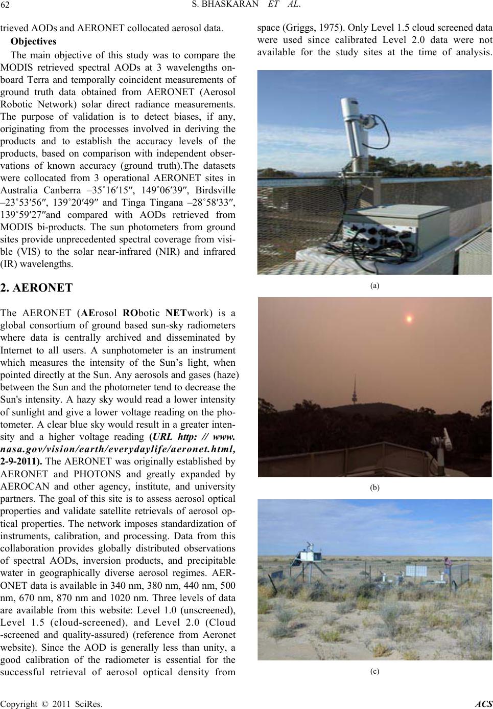 62 S. BHASKARAN ET AL. trieved AODs and AERONET collocated aerosol data. Objectives The main objective of this study was to compare the MODIS retrieved spectral AODs at 3 wavelengths on- board Terra and temporally coincident measurements of ground truth data obtained from AERONET (Aerosol Robotic Network) solar direct radiance measurements. The purpose of validation is to detect biases, if any, originating from the processes involved in deriving the products and to establish the accuracy levels of the products, based on comparison with independent obser- vations of known accuracy (ground truth).The datasets were collocated from 3 operational AERONET sites in Australia Canberra –35˚16′15″, 149˚06′39″, Birdsville –23˚53′56″, 139˚20′49″ and Tinga Tingana –28˚58′33″, 139˚59′27″and compared with AODs retrieved from MODIS bi-products. The sun photometers from ground sites provide unprecedented spectral coverage from visi- ble (VIS) to the solar near-infrared (NIR) and infrared (IR) wavelengths. 2. AERONET The AERONET (AErosol RObotic NETwork) is a global consortium of ground based sun-sky radiometers where data is centrally archived and disseminated by Internet to all users. A sunphotometer is an instrument which measures the intensity of the Sun’s light, when pointed directly at the Sun. Any aerosols and gases (haze) between the Sun and the photometer tend to decrease the Sun's intensity. A hazy sky would read a lower intensity of sunlight and give a lower voltage reading on the pho- tometer. A clear blue sky would result in a greater inten- sity and a higher voltage reading (URL http: // www. nasa.gov/vision/earth/everydaylife/aeronet.html, 2-9-2011). The AERONET was originally established by AERONET and PHOTONS and greatly expanded by AEROCAN and other agency, institute, and university partners. The goal of this site is to assess aerosol optical properties and validate satellite retrievals of aerosol op- tical properties. The network imposes standardization of instruments, calibration, and processing. Data from this collaboration provides globally distributed observations of spectral AODs, inversion products, and precipitable water in geographically diverse aerosol regimes. AER- ONET data is available in 340 nm, 380 nm, 440 nm, 500 nm, 670 nm, 870 nm and 1020 nm. Three levels of data are available from this website: Level 1.0 (unscreened), Level 1.5 (cloud-screened), and Level 2.0 (Cloud -screened and quality-assured) (reference from Aeronet website). Since the AOD is generally less than unity, a good calibration of the radiometer is essential for the successful retrieval of aerosol optical density from space (Griggs, 1975). Only Level 1.5 cloud screened data were used since calibrated Level 2.0 data were not available for the study sites at the time of analysis. (a) (b) (c) Copyright © 2011 SciRes. ACS  S. BHASKARAN ET AL. 63 (d) (e) Figure 1. (a) A view of the instrument and site in Canberra; (b) A view of the sun photom eter and the sun taken during a January 2003 firestorm, Site: Canberra; (c) Sun pho- tometer in a weather station enclosure at a local airport, Site: Birdsville; (d) A view of the instrument site and sur- rounding terrain, Site: Birdsville; (e) A close-up view of the instrument platform and sun photometer, Site: Inga Tin- gana (with a hawk on top). 3. Study Sites Canberra (–35˚16′15″, 149˚06′39″; Elevation –600 mts) is located in the Australian Capital Territory, Birdsville and Tinga Tingana sites in Australia were selected for the study. The site began collecting data from the 15thJanuary, 2003 and the operational time is 1038 Days [2.844 years]. The sun photometer is mounted on the roof of the two-storey CSIRO lab in Australia’s capital city, Canberra. Data was collected at the Birdsville (23˚5356, 139˚ 20′49″; Elevation –46.5 mts) site on the 13thAugust, 2005. The site has been in operational mode for 269 Days. Birdsville is located near the maximum of dust storm frequency on the continent. It lies just east of the Simp- son desert, and to the north of the Strzelecki desert (where TT is located) so receives dust from the prevail- ing southerly and westerly winds. The third site selected for this study in Australia is Tinga Tingana (28˚58′33″, 139˚59′27″; Elevation –38.0 mts). Data has been col- lected from this site since the 3rd January, 1993 and the site has been in operation for 1727 Days. The Tinga Tingana site is enclosed within a fence in a desert region in Tinga Tingana, Australia. The CSIRO is responsible for the instruments and all AERONET sites in Australia are managed by a PI from CSIRO, Canberra. 4. Methodology A spatial-temporal approach demonstrated by Ichoku et. al. (2002a) was employed for this study. Twenty two (22) raw Full Swath L1B MODIS packet data sets (pds) were acquired from the ACRES digital catalogue for the time period between January, 2005 to December, 2005 over the three (3) selected study sites in Australia. The MODIS scenes were acquired by using series of near coincident Landsat ETM scenes from the ACRES digital catalogue software. The pds MODIS scenes were proc- essed by using a modified version of MOD09 atmos- pheric processing algorithm (originally from NASA).The product is an estimate of the surface spectral reflectance for each band as it would have been measured at ground level if there were no atmospheric scattering or absorp- tion. It includes corrections for the effect of atmospheric gases, aerosol, and thin cirrus clouds and provides inputs to NDVI, EVI and BRDF. MOD09 permits rigorous temporal comparison and cross calibration with other sensors including AVHRR, Landsat and ASTER which leads to better exploitation of ACRES archive. The MODIS surface reflectance product (MOD09), is a seven-band product computed from the MODIS Level 1B land bands 1, 2, 3, 4, 5, 6, and 7. Tab le 1 and Tab l e 2 show the number of bands used by MOD09 in the re- trieval process, and the total number of MODIS passes used in the study respectively. The entire MOD09 work flow process is shown on Figure 2. The AODs were retrieved at 3 wavelengths (Band1: 620 - 670 nm; Band3: 450 - 479 nm and Band8: 405 - 420 nm) respectively from the MOD09 atmospheric cor- rection algorithm. At ACRES, AOD products are generated Table 1. MOD09 Bands • Band1 648 nm • Band2 858 nm • Band3 470 nm • Band4 555 nm • Band5 1240 nm • Band6 1640 nm • Band7 2130 nm Copyright © 2011 SciRes. ACS  S. BHASKARAN ET AL. Copyright © 2011 SciRes. ACS 64 Table 2. Time series of MODIS scenes and information. SNo Acquisition date Orbit No Ancillary data usedAeronet site namesSolar Zenith Angle (sza) Canberra and Birdsville 1 04-03-2005 27707 TOVS Canberra 0.62° 2 08-06-2005 29105 Not Available Canberra 1.96° 3 15-01-2005 27008 TOVS Canberra Geolocation error 4 16-02-2005 27474 TOVS Canberra Geolocation error 5 17-12-2005 31901 TOAST Canberra 3.11° 6 20-03-2005 27940 TOVS Canberra 0.78° 7 23-5-2005 28872 TOVS Canberra 3.65° 8 02-07-2005 29455 TOAST Birdsville/Tinga 6.67° 9 03-08-2005 29921 TOAST Birdsville/Tinga 3.44° 10 04-09-2005 30387 TOAST Birdsville/Tinga 3.33° 11 07-11-2005 31319 TOAST Birdsville/Tinga 2.17° 12 12-03-2005 27824 TOVS Birdsville/Tinga 9.02° 13 13-04-2005 28290 TOVS Birdsville/Tinga 4.05° 14 15-05-2005 28756 TOVS Birdsville/Tinga 6.94° 15 16-06-2005 29222 TOAST Birdsville/Tinga 5.85° 16 18-07-2006 29688 TOAST Birdsville/Tinga 3.54° 17 19-08-2005 30154 TOAST Birdsville/Tinga 7.39° 18 20-09-2005 30620 TOAST Birdsville/Tinga 3.96° 19 22-10-2005 31086 TOAST Birdsville/Tinga 3.88° 20 28-03-2005 28057 TOVS Birdsville/Tinga 5.85° 21 29-04-2005 28523 TOVS Birdsville/Tinga 4.23° 22 31-05-2005 28989 TOVS Birdsville/Tinga 4.51° Figure 2. MOD09 Atmospheric correction process work flow to generate a full single swath at ACRES, Australia. in 3 different formats - ER Mapper he differences in their data structures. MODIS covers an extensive area across a given AERONET instrument site almost in an instant, whereas the AERONET sun photometer takes point measurements several times during the daytime. MODIS expresses spatial variability, AERONET expresses tem- poral variability (Ichoku et.al, 2004). The AOD values for all the 3 sites were collocated and extracted over all 3 sites at a coarse and fine spatial resolution by using both spatial windows of 50 km by 50 km and 10 km by 10 km (Kaufman et.al, 2000). The MODIS retrieved AODs were then compared by plotting them against the AODs retrieved from AERONET for all 3 sites for the year 2005. PDS Attitude and Ephemeris Seadas Level 1 Processor 5. Aerosol Comparison - Results and Discussions: GDAS-Surface Pressure and Temperature TOASTS and TOVS - Ozone MOD09 Spatial and temporal distribution of MODIS and Aeronet AODs over Canberra, Birdsville and Tinga Tingana for the year 2005 A spatial-temporal approach based on Ichoku (2002a) was employed to validate MODIS AOD retrievals in this study. MODIS retrieved AODs for 3 wavelengths (405 - 420 nm, 450 - 479 nm and 620 - 670 nm) were plotted against temporally coincident AERONET retrieved AODs. Figures 3 (a)-(d) below shows the graphs for the 3 sites for the year 2005. Spatial and temporal trends of aerosol retrievals from MODIS and AERONET for Canberra, Birdsville and Tinga Tingana sites in Australia for year 2005 are described in the following paragraphs. A generally observation is that MODIS retrievals overes- timates for low aerosols and underestimates for higher AOD. AODs were extracted for variable spatial windows of 50 km by 50 km and 10 km by 10 km from the MODIS scenes. The solar zenith angle (sza) of each scenes were recorded to provide a qualitative estimate of the angular variations of AOD retrievals. The statistics (mean, median, standard deviation) were generated for GeoTIFF Map O r iented MRT Swath Map Projection MOD09 HDF Swath  S. BHASKARAN ET AL. 65 each scenes and were plotted against the 3 wavelengths of AERONET (380 nm, 440 nm and 675 nm) and MODIS spectral bands (center wavelengths). The distribution of AODs (MODIS retrievals) were also mapped for all scenes to display the concentrations of high and low aerosol depths over the 3 study sites. 5.1. Spatio-temporal Distribution of AOD in Canberra – 2005 Yearly trend in spectral AODs retrieved by both MODIS and Aeronet over Canberra shows that AOD is low in the beginning of year and peaks during mid year period (May-June, 2005). High concentrations of AERONET AODs (0.40 and 0.10) are found in the months of May and June which reduces towards the end of the year. For these two months AERONET sun photometer estimates are significantly higher compared to MODIS retrieved AODs. This may be attributed to the increase in mid year bush fires which engulfed Canberra in 2005. The MODIS retrievals generally are overestimated for all the months compared to the AODs retrieved by the sun pho- tometer instrument in Canberra. Overall estimates for both MODIS and AERONET are generally low for (a) (b) (c) (d) (e) Figure 3. (a) Spatial distribution of AOD retrievals from MODIS: Band 1 over Canberra – 4 March, 2005. (b) Spa- tial distribution of AOD retrievals from MODIS: Band 1 over Canberra – 23rd March, 2005. (c) Spatial distribution of AOD retrievals from MODIS: Band 1 over Canberra – 8th June, 2005. (d) Spatial distribution of AOD retrievals from MODIS: Band 1 over Birdsville – 12th March, 2005.(e) Spatial distribution of AOD retrievals from MODIS: Band 1 over Birdsville – 12th March, 2005. Canberra expect for May, 2005 where the MODIS and Aeronet AODs reach a peak of 0.60 and 0.40 respec- tively. Copyright © 2011 SciRes. ACS  66 S. BHASKARAN ET AL. 5.2. Spatio-temporal Distribution of AOD in Birdsville, 2005 For Birsdville in general MODIS retrievals overestimate AODs. For instance for 12th March, 2005 MODIS more than Aeronet retrievals by 0.02 except at 440 nm - 470 nm where MODIS retrievals are underestimated to the Aeronet AODs. 28thMarch, 2005: MODIS retrievals overestimate AOD at 470 nm but run close to Aeronet retrievals for the other wavelengths. 13thApril, 2006 MODIS retrievals overestimate AODs at 412 nm and 470 nm but underestimate at 659 nm. 29th April: MODIS retrievals underestimate AODs at 412 nm and 659 nm, but overestimate at 470 nm.15thMay, 2005: MODIS retrievals underestimate AODs at 412 nm and 659 nm but overestimate at 470 nm 31stMay, 2005: MODIS retrievals underestimate AOD at 412 nm and 659 nm but overestimate at 470 nm MODIS retrievals underestimate at all wavelengths. 2ndJuly,2005: MODIS underestimates at 412 nm and 470 nm but overestimates at 675 nm marginally. 18th July,2005: MODIS retrievals underestimate AODs at 412 nm and 659 nm but overes- timate at 470 nm. For the months of August, September, and October MODIS retrievals underestimate Aeronet retrievals at all the wavelengths. 5.3. Spatio-temporal Distribution of AOD in Tinga Tingana – 2005 MODIS retrievals overestimate Aeronet retrievals for all wavelengths but for certain months the opposite trend is observed particularly for in the months of October and November, 2005 where the MODIS retrievals are under- estimated by Aeronet estimates. Some months the MODIS and Aeronet estimates underestimate at some wavelengths but overestimate at others. For instance on 12th March, 2005 the MODIS retrievals match Aeronet at 380 - 412 nm (Figure 3 (e)) but overestimates at 440 - 470 nm and underestimates at 659 - 675 nm wavelength. On 28th March, 2005 the MODIS retrievals overestimate the Aeronet retrievals at all wavelengths. On the 13th April, 2005 the MODIS retrievals underestimate the Aeronet estimates at 380 - 412 nm and 659 - 675 nm wavelengths, but between 440 – 470 nm wavelengths the MODIS retrievals match the Aeronet retrievals. On 15th May,2005 the MODIS retrievals overestimate the Aer- onet retrievals at all wavelengths and on the 2ndJuly, 2005 the MODIS retrievals underestimate at 380 - 412 wavelength, but overestimate the Aeronet retrievals at the 440 - 470 nm and 659 - 675 nm wavelengths. On the 18thJuly, 2005 the MODIS retrievals underestimate AODs at 412 nm and 659 nm but overestimate at 470 nm. On 3rdAugust, 2005 the MODIS retrievals overestimate Aeronet retrievals for all the wavelengths. On the 4thSeptember, 2005 the MODIS retrievals un- derestimate the Aeronet retrievals for all wavelengths. On 22ndOctober and 7thNovember, 2005 the MODIS re- trievals underestimate the Aeronet retrievals for all wavelengths. 6. Conclusions Yearly data sets were compared in this study over three sites in Australia using level 1.5 cloud free data. The MODIS retrieved AOD overestimates compared with the Aeronet retrievals. The results also may be affected by the numerous problems posed to aerosol retrieval by the surface background over land and the potential sampling mismatch in comparing averages from MODIS spatially variable data space and AERONET temporally variable data space. There were some limitations that may have contributed to the accuracy of validation. AOD is gener- ally less than unity, a good calibration of the radiometer is essential for the successful retrieval of aerosol optical density from space. Calibrated Aeronet data (Level 2.0) was not available over the 3 study sites which further reduced the accuracy of the study. It is important to un- derstand the proportion of trace gases like water vapour, carbon dioxide which absorb solar radiation in the 1600, 2100 nm wavelengths. Estimating AODs is a challenging research investigation due to the highly variable spatial and temporal dimensions of AODs. Some changes in the internal instrument temperature are also some cause of false signals in sun photometers. Calibration of sites is a complex process and efforts are underway in Australia to provide calibrated AOD data which we hope this will further enhance the accuracy of results presented in this study. Despite these limitations in the assessment a general conclusion is that MODIS AODs tend to overestimate the AODs particularly over land. 7. Acknowledgements The authors would like to thank the PI and staff at CSIRO for establishing and maintaining the AERONET sites used in this study. 8. References [1] Griggs, M., 1975: Measurement of atmospheric aerosol optical thickness over water using ERTS-1 data. J.Air Pollut.Contr. Assoc., 25, 622-626. [2] Hauser, A., Oesch, D., Foppa, N., Aerosol optical depth over land: Comparing AERONET, AVHRR and MODIS. Geophysical Research Letters, Vol. 32, LXXXXX, doi: 10.1029/2005GL023579, 2005 Copyright © 2011 SciRes. ACS  S. BHASKARAN ET AL. Copyright © 2011 SciRes. ACS 67 [3] Ichoku, C., D. A. Chu, S.Matoo, Y.J. Kaufman, L.A.Remer, D.Tanre, I.Slutsker, and B.N.Holben, 2002a: A spatio-temporal approach for global validation and analysis of MODIS aerosol products. Geophys. Res, Lett., 29, 8006, doi:10.1029/2001GL013206. [4] Ichoku, C., Remer, L.A., Eck, F.T, 2004. Quantitative evaluation and intercomparison of morning and afternoon MODIS aerosol measurements from Terra and Aqua Sat- ellites. Journal of Geophysical Research, JGR (Special Issue on: “Global Aerosol System”. [5] King, D, M., Kaufman, Y.J., Tanre, D., Nakajima, T, 1999, Remote sensing of tropospheric aerosols from space: past, present and future. Bulletin of the American Meteorological Society. [6] Kaufman, Y.J., B.N.Holben., D, Tanre., i.Slutsker., a. Smirnov., and T.F. Eck, 2000, Will aerosol measurements from Terra and Aqua polar orbiting satellites represent the daily aerosol abundance and properties, Geophys. Res. Letters, 27, 3861-3864, 2000. [7] Kaufman, Y.J., B.N.Holben., D. Tanre., and O. Boucher, A satellite view of aerosols in the climate system, Nature, 419, 215-223, 2002 |