

Paper Menu >>
Journal Menu >>
 Communications and Network, 2013, 5, 678-680 http://dx.doi.org/10.4236/cn.2013.53B2121 Published Online September 2013 (http://www.scirp.org/journal/cn) The Application of Ontol ogy in Semantic Discovery for GeoData Web Service Mingwu Guo1,2 1Key Laboratory of Precise Engineering and Industry Surveying, National Administration of Surveying, Mapping and Geoinformation, Wuhan, China 2Wuhan Geomatic Institute, Wuhan, China Email: [email protected] Received July 2013 ABSTRACT GeoData Web service is an important way to achieve the integration and sharing of heterogeneous geospatial data at present. However, due to the complexity of GeoData and no sematic supporting Webservice discovery, it is very hard for data users to accurately find the GeoData WebService they really want. In order to make it easy for users to quickly and accurately find the G eoData Web Service they want in semantic level, this article firstly, constructs MetaData On- tololy, and uses MetaData Ontology to describe the related semantic information for GeoData Web Service. Then it comes up with a new way of computing the degree of semantic similarity among concepts based on Ontology. Finally, it realizes the automatic discovery for GeoData Web Service based on semantic matching. The experiment result shows that the way in this article can dramatically improve the accuracy and intelligence of GeoData Web Service discovery. Keywords: GeoData WebService; Semantic Discovery; Ontology 1. Introduction At present, GeoData Web service is an important way to achieve the integration and sharing of heterogeneous geospatial data. In order to access the geospatial data they need, GeoData users usually have to try to find the GeoData Web Service fro m the Intern et. But us ually, it is very difficult for GeoData users to accurately find the GeoData Web Service they need [1]. The complexity and diversity of GeoData itself is the one reason. Another pri- ncipal reason is that, present GeoData Web Service main- ly follows the OGC specif ication, such as WMS, WFC or WCS, etc. [2]. And to find the data service can only be achieved by the matching of keywords for the service, rather than by semantic query. The research of semantic description and semantic discovery for GeoData Web Service is absent. So, this article researches the semantic description and discovery of GeoData Web Service and puts forwa r d a solution based on Me taData Ontology. 2. MetaData Ontology and Its Semantic Description for GeoData Service In order to make the computer understand GeoData se- mantically, and to make it easy for computers and users to find their needed geospatial data service in semantic level, this article constructs MetaData Ontology. The Me- taData Ontology describing geographical data service from all aspects, in semantic level, such as the URL of the service, the name of data service, the layer name, the data extent of the data service, the data category, the coordi- nate system, the project system and so on. The main structure of the constructed MetaData Ontology is pre- sented in Figure 1. Partial Description of MetaData Ontology in OWL Language as follow: <owl:Class rdf:ID=“MetaData”/> <owl:DatatypeProperty rdf:ID=“DataName”> <rdfs:domain rdf:resource=“# MetaData”/> <rdfs:range rdf:resource=“http://www.w3.org/2001/XMLSchema#str ing”/> </owl:DatatypeProperty> <owl:DatatypeProp erty rdf:ID=“Url”> <rdfs:domain rdf:resource=“# MetaData”/> <rdfs:range rdf:resource=“http://www.w3.org/2001/XMLSchema#str ing”/> </owl:DatatypeProperty> <owl:ObjectProp erty rdf:ID=“DataExtent”> <rdfs:domain rdf:resource=“# MetaData”/> <rdfs:range rdf:resource=“# CoordinateExtent”/> </owl:ObjectProperty> Copyright © 2013 SciRes. CN 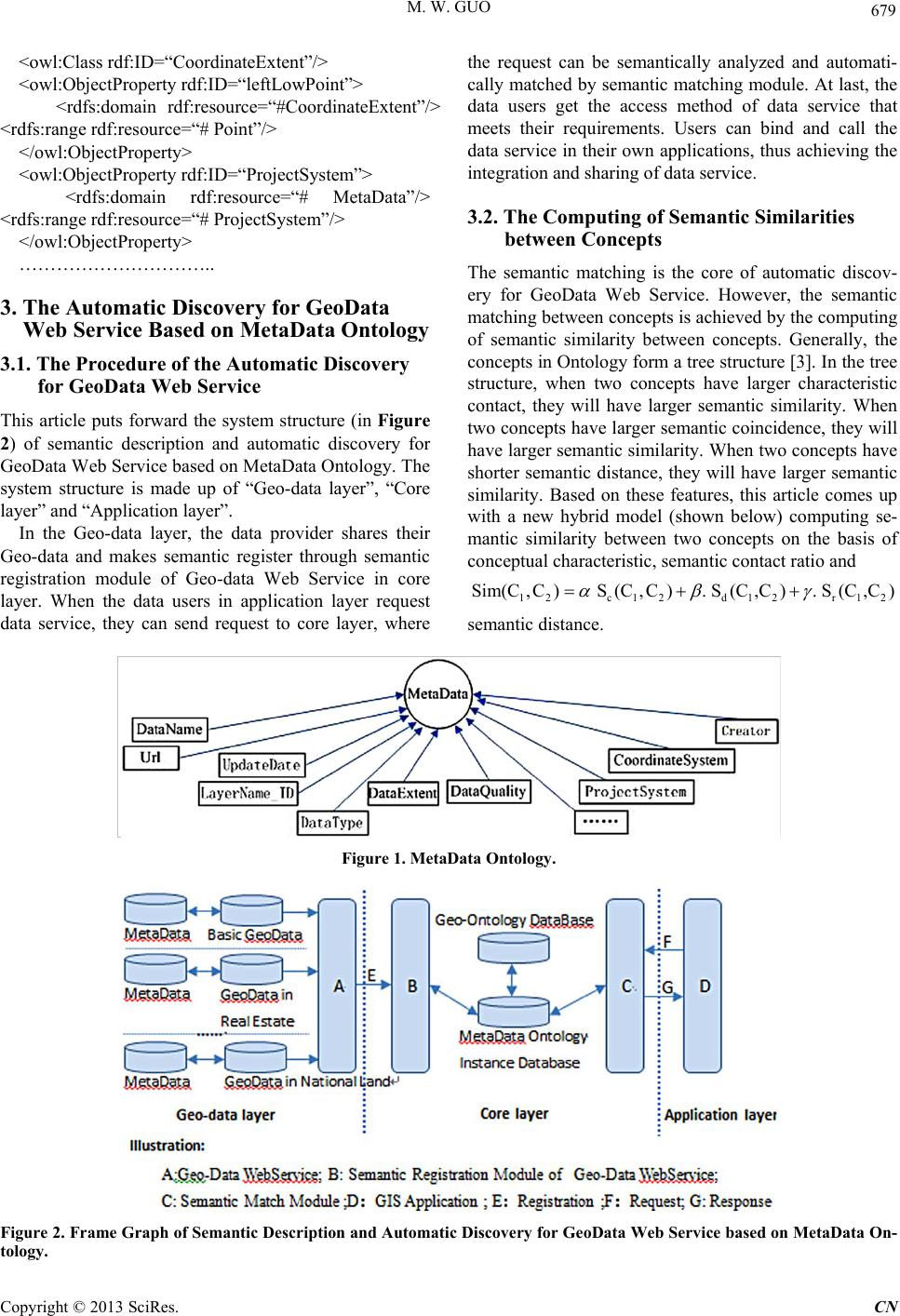 M. W. GUO 679 <owl:Class rdf:ID=“CoordinateExtent”/> <owl:ObjectProp erty rdf:ID=“leftLowPoint”> <rdfs:domain rdf:resource=“#CoordinateExtent”/> <rdfs:range rdf: re s ource=“ # Point”/ > </owl:ObjectProperty> <owl:ObjectProp erty rdf:ID=“ProjectSystem”> <rdfs:domain rdf:resource=“# MetaData”/> <rdfs:range rdf:resource=“# ProjectSystem”/> </owl:ObjectProp e r ty> ………………………….. 3. The Automatic Discovery for GeoData Web Service Based on MetaData Ontology 3.1. The Procedure of the Automatic Disco very for GeoData Web Service This article puts forward the system structure (in Figure 2) of semantic description and automatic discovery for GeoData Web Service based on MetaData Ontology. The system structure is made up of “G eo-data layer”, “Core layer” and “Application layer”. In the Geo-data layer, the data provider shares their Geo-data and makes semantic register through semantic registration module of Geo-data Web Service in core layer. When the data users in application layer request data service, they can send request to core layer, where the request can be semantically analyzed and automati- cally matched by semantic matching module. At last, the data users get the access method of data service that meets their requirements. Users can bind and call the data service in their ow n applications, thus achieving the integration and sharing of data service. 3.2. The Computing of Semantic Similarities between Concepts The semantic matching is the core of automatic discov- ery for GeoData Web Service. However, the semantic matching between concepts is achieved by the computing of semantic similarity between concepts. Generally, the concepts in Ontology form a tree structure [3]. In the tree structure, when two concepts have larger characteristic contact, they will have larger semantic similarity. When two concepts have larger semantic coincidence, the y will have larger semantic similarity. When two concepts have shorter semantic distance, they will have larger semantic similarity. Based on these features, this article comes up with a new hybrid model (shown below) computing se- mantic similarity between two concepts on the basis of conceptual characteristic, semantic contact ratio and 1 2c1 2d 12r 12 Sim(C,C) S(C,C). S(C,C). S(C,C) αβγ =++ semantic distance. Figure 1. MetaData Ontology. Figure 2. Frame Graph of Semantic Description and Automatic Discovery for GeoData Web Service based on MetaData On- tology. Copyright © 2013 SciRes. CN 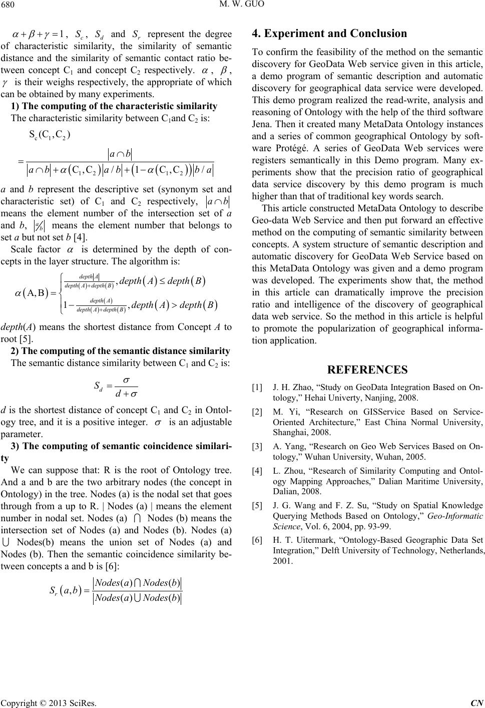 M. W. GUO 680 1 αβγ ++= , c S , d S and r S represent the degree of characteristic similarity, the similarity of semantic distance and the similarity of semantic contact ratio be- tween concept C1 and concept C2 respectively. α , β , γ is their weighs respectively, the appropriate of which can be obtained by many expe ri ments . 1) The computing of the characteristic similarity The characteristic similarity between C1and C2 is: ( )( ) ( ) c12 12 12 S(C,C) C ,C/1C,C/ ab a babba αα ∩ =∩+ +− a and b represent the descriptive set (synonym set and characteristic set) of C1 and C2 respectively, ab∩ means the element number of the intersection set of a and b, ab means the element number that belongs to set a but not set b [4]. Scale factor α is determined by the depth of con- cepts in the layer structure. The algorithm is: ( ) ( )( ) ( )( ) ( ) ( )( ) ( )( ) , ,1, depth A depth Adepth B depth A depth Adepth B depthAdepth B depthAdepth B α + + ≤ ΑΒ = −> depth(A) means the shortest distance from Concept A to root [5]. 2) The computing of the semantic distance similarity The semantic distance similarity between C1 and C2 is: d Sd σ σ =+ d is the shortest distance of concept C1 and C2 in Ontol- ogy tree, and it is a positive integer. σ is an adjustable parameter. 3) The computing of semantic coincidence similari- ty We can suppose that: R is the root of Ontology tree. And a and b are the two arbitrary nodes (the concept in Ontology) in the tree. Nodes (a) is the nodal set that goes through from a up to R. | Nodes (a) | means the element number in nodal set. Nodes (a) Nodes (b) means the intersection set of Nodes (a) and Nodes (b). Nodes (a) Nodes(b) means the union set of Nodes (a) and Nodes (b). Then the semantic coincidence similarity be- tween concepts a and b is [6]: ( ) () () ,() () r NodesaNodes b S abNodes aNodes b = 4. Experiment and Conclusion To confirm the feasibility of the method on the semantic discovery for GeoData Web service given in this article, a demo program of semantic description and automatic discovery for geographical data service were developed. This demo program realized the read-write, analysis and reasoning of Ontology with the help of the third software Jena. Then it created many MetaData Ontology instances and a series of common geographical Ontology by soft- ware Protégé. A series of GeoData Web services were registers semantically in this Demo program. Many ex- periments show that the precision ratio of geographical data service discovery by this demo program is much higher than that of traditional key words search. This article constructed MetaData Ontology to describe Geo-data Web Service and then put forward an effective method on the computing of semantic similarity between concepts. A system structure of semantic description and automatic discovery for GeoData Web Service based on this MetaData Ontology was given and a demo program was developed. The experiments show that, the method in this article can dramatically improve the precision ratio and intelligence of the discovery of geographical data web service. So the method in this article is helpful to promote the popularization of geographical informa- tion application. REFERENCES [1] J. H. Zhao, “Study on GeoData Integration Based on On- tology,” Hehai Univerty, Nanjing, 2008. [2] M. Yi, “Research on GISService Based on Service- Oriented Architecture,” East China Normal University, Shanghai, 2008. [3] A. Yang, “Research on Geo Web Services Based on On- tology,” Wuhan University, Wuhan, 2005. [4] L. Zhou, “Research of Similarity Computing and Ontol- ogy Mapping Approaches,” Dalian Maritime University, Dalian, 2008. [5] J. G. Wang and F. Z. Su, “Study on Spatial Knowledge Querying Methods Based on Ontology,” Geo-Informatic Science, Vol. 6, 2004, pp. 93-99. [6] H. T. Uitermark, “Ontology-Based Geographic Data Set Integration,” Delft University of Technology, Netherlands, 2001. Copyright © 2013 SciRes. CN |