

Paper Menu >>
Journal Menu >>
 Open Journal of Soil Science, 2012, 2, 28-32 http://dx.doi.org/10.4236/ojss.2012.21005 Published Online March 2012 (http://www.SciRP.org/journal/ojss) Soil Erosion around Foundations of Houses in Four Communities in Ghana Kofi Agyarko*, Joseph Adu, Daniel Gyasi, Samuel Kumi, Lydia Mensah College of Agriculture Education, University of Education, Winneba, Ghana. Email: *[email protected] Received December 20th, 2011; revised January 23rd, 2012; accepted February 4th, 2012 ABSTRACT Soil erosion studies around houses in four communities in Ghana were carried out from August to November, 2010. Thirty houses were selected from each of the four communities for the study. Measurements of slope and the depth of exposed foundatio n of houses were don e with the help of a string and a tap e measure. Data were also obtained through questionnaire an d interview of house owners. The Pear son’s correlation coefficient was used to measure some relation- ships among data. In the selection of site for building a house, higher percentage of the house owners considered no factor. The major cleaning activity around the surrounding of houses was noted to be sweeping with a broom. All the houses in the communities had their foundations exposed, 57% - 93% of the houses had exposed foundations up to a lev el w it h in 5 1 - 10 0 cm which was classified as “Severely Exposed”. Th e e x ten t of bu i ld i ng fo un d a t io n ex p o s ed b y so il erosion was found to be positively correlated with the age of bu ilding and th e slope of the land . Most of the respo ndents controlled soil erosion by blocking water ways with materials such as, sand heaps, stones and sacks filled with soil. Only 10% of the respondents from one of the communities planted grasses around their houses to control soil erosion. Communities need to be educated to plant grasses around their houses to beautify the surroundings and to control soil erosion. Keywords: Soil Erosion; Foundations; Houses; Exposed 1. Introduction Soil, a thin layer that covers most of the earth’s land sur- face might appear insignificant relative to the bulk of the earth, yet it is in this thin layer of soil that living king- doms establish a dynamic relationship [1]. Soil is an im- portant natural resource which is vital for all living or- ganisms as major ecosystems, as well as for food produc- tion, development and growth of settlements and popula- tion distribution. However, this layer is gradually being destroyed from its natural state through erosion as a re- sult of man’s activities in searching for a better living condition. Soil erosion causes tremendous damage to about one-thir d of world’s cropland [2]. Global Assessment of Soil Degradation (GLASOD) study estimated that about 15 per cent of the earth’s ice- free land surface is afflicted by all for ms of land degrad a- tion. Of this, accelerated soil erosion by water is respon- sible for about 56 per cent and wind erosion is response- ble for about 28 percent. This means that the area af- fected by water erosion is, around 11 million square km, and the area affected by wind erosion is around 5.5 mil- lion square km [3]. About 80% of the World’s agricultural land suffers moderate to severe erosion and 10% suffers slight to mo- derate erosion. Soil erosion rates may exceed 100 ton per ha per year in severely overgrazed pastures [4]. Effects of erosion are enormous. At the household level, the onsite effects include damages to buildings, damages to drains and roads, destruction of landscape, and causing of flood. Erosion exposes building foundations which warrant routine repair of houses. In some cases erosion causes complete collapse of buildings and those build- ings must be rebuilt and this adds to the expenditure of poor households. Sometimes erosion renders households homeless if houses collapse [5]. Some houses in older communities of Ghana are ob- served to have their foundations dangerously exposed by soil erosio n. The p aper attemp ts to assess th e exten t of soi l erosion of foundation of houses and the steps taken to solve this problem by house owners in four communities in Ghana. 2. Materials and Methods The study was conducted in four communities in Ghana, *Corresponding a uthor. Copyright © 2012 SciRes. OJSS 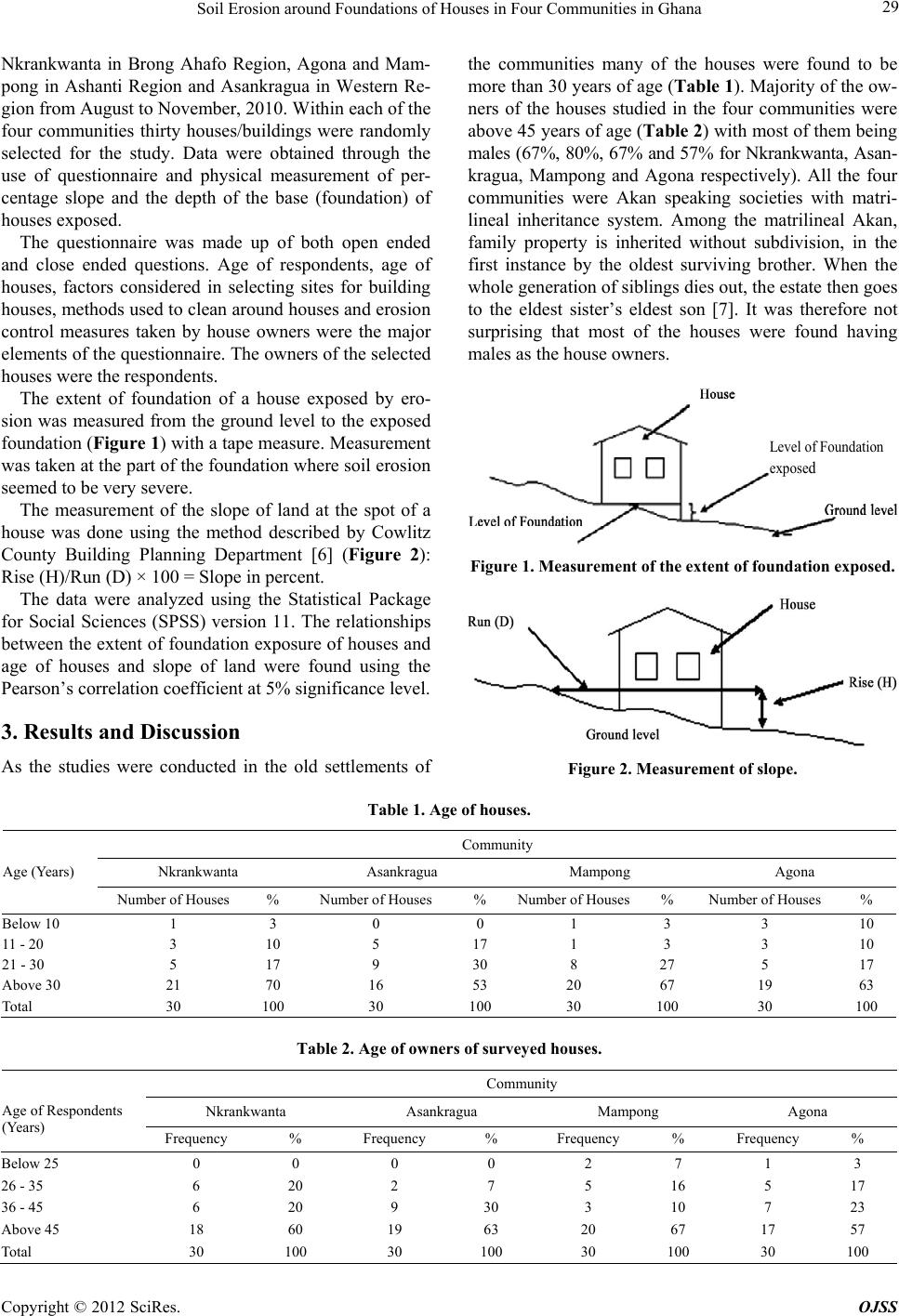 Soil Erosion around Foundations of Houses in Four Communities in Ghana 29 Nkrankwanta in Brong Ahafo Region, Agona and Mam- pong in Ashanti Region and Asankragua in Western Re- gion from August to November, 2010. Within each of the four communities thirty houses/buildings were randomly selected for the study. Data were obtained through the use of questionnaire and physical measurement of per- centage slope and the depth of the base (foundation) of houses exposed. The questionnaire was made up of both open ended and close ended questions. Age of respondents, age of houses, factors considered in selecting sites for building houses, methods used to clean around houses and erosion control measures taken by house owners were the major elements of the questionnaire. The owners of the selected houses were the respondents. The extent of foundation of a house exposed by ero- sion was measured from the ground level to the exposed foundation (Figure 1) with a tape measure. Measurement was taken at the part of the foundation where soil erosion seemed to be very severe. The measurement of the slope of land at the spot of a house was done using the method described by Cowlitz County Building Planning Department [6] (Figure 2): Rise (H)/Run (D) × 100 = Slope in percent. The data were analyzed using the Statistical Package for Social Sciences (SPSS) version 11. The relationships between the exten t of foundation exposure of houses an d age of houses and slope of land were found using the Pearson’s correlation coefficient at 5% significance level. 3. Results and Discussion As the studies were conducted in the old settlements of the communities many of the houses were found to be more than 30 years of age (Table 1). Majority of the ow- ners of the houses studied in the four communities were above 45 years of age (Ta ble 2) with most of them being males (67%, 80%, 67% and 57% for Nkrankwanta, Asan- kragua, Mampong and Agona respectively). All the four communities were Akan speaking societies with matri- lineal inheritance system. Among the matrilineal Akan, family property is inherited without subdivision, in the first instance by the oldest surviving brother. When the whole generation of siblings dies out, the estate then goes to the eldest sister’s eldest son [7]. It was therefore not surprising that most of the houses were found having males as the house owners. Level of Foundation expose d Figure 1. Measurement of the extent of foundation exposed. Figure 2. Measurement of slope. Table 1. Age of houses. Community Nkrankwanta Asankragua Mampong Agona Age (Years) Number of Houses % Number of Houses % Number of Houses% Number of Houses % Below 10 1 3 0 0 1 3 310 11 - 20 3 10 5 17 1 3 310 21 - 30 5 17 9 30 8 27 517 Above 30 21 70 16 53 20 67 1963 Total 30 100 30 100 30 100 30100 Table 2. Age of owners of surveyed houses. Community Nkrankwanta Asankragua Mampong Agona Age of Respondents (Years) Frequency % Frequency % Frequency % Frequency % Below 25 0 0 0 0 2 7 1 3 26 - 35 6 20 2 7 5 16 5 17 36 - 45 6 20 9 30 3 10 7 23 Above 45 18 60 19 63 20 67 17 57 Total 30 100 30 100 30 100 30 100 Copyright © 2012 SciRes. OJSS 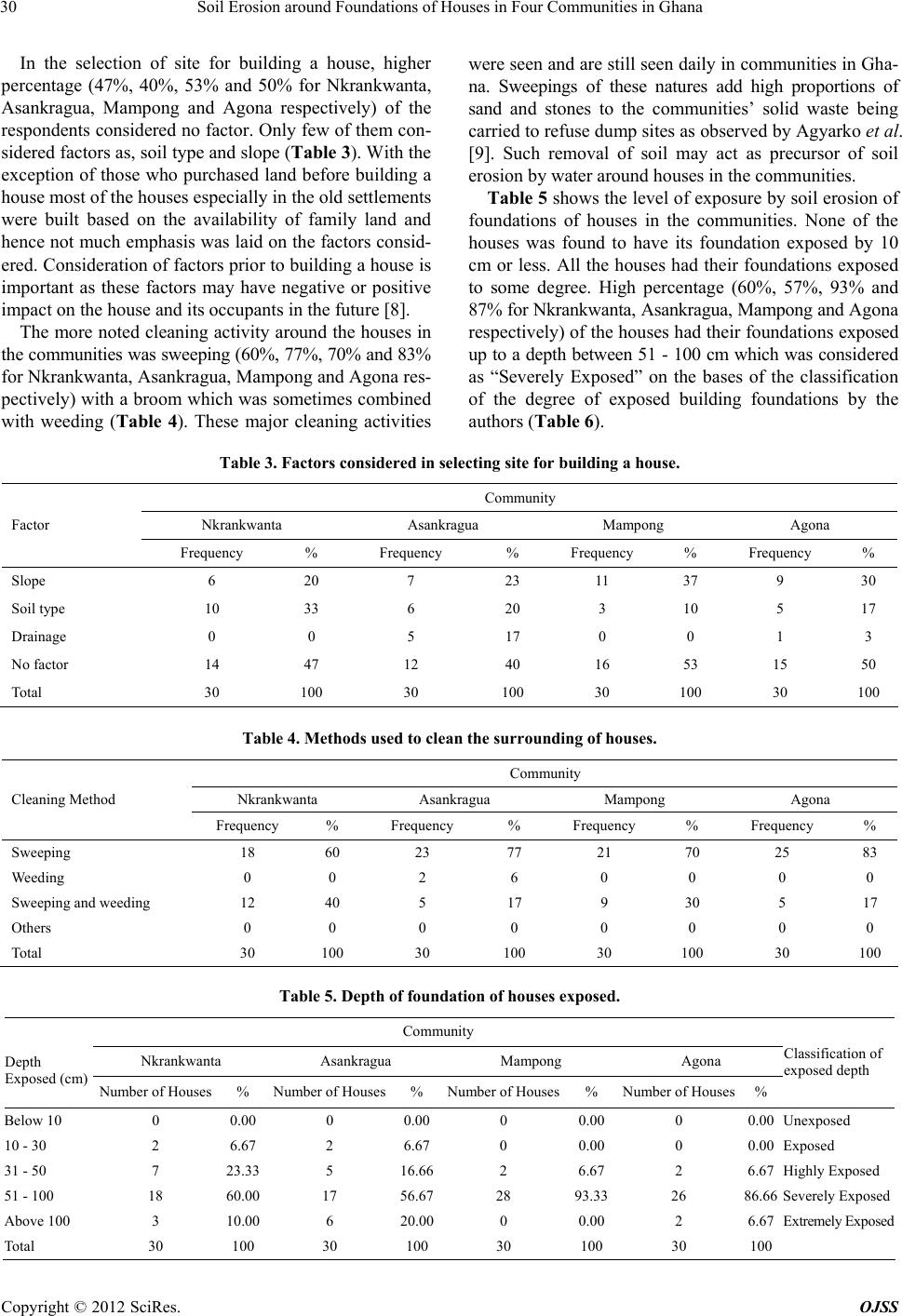 Soil Erosion around Foundations of Houses in Four Communities in Ghana 30 In the selection of site for building a house, higher percentage (47%, 40%, 53% and 50% for Nkrankwanta, Asankragua, Mampong and Agona respectively) of the respondents considered no factor. Only few of them con- sidered factors as, soil type and slope (Table 3). With th e exception of those who purchased land before building a house most of the houses especially in the old settlements were built based on the availability of family land and hence not much emphasis was laid on the factors consid- ered. Consideration of factors prior to building a house is important as these factors may have negative or positive impact on the house and its occupants in the future [8]. The more noted cleaning activity around the houses in the communities was sweeping (60%, 77%, 70% and 83% for Nkrankwanta, Asankragua, Mampong and Agona res- pectively) with a broom which was sometimes combined with weeding (Table 4). These major cleaning activities were seen and are still seen daily in communities in Gha- na. Sweepings of these natures add high proportions of sand and stones to the communities’ solid waste being carried to refuse dump sites as ob served b y Agyarko et al. [9]. Such removal of soil may act as precursor of soil erosion by water around houses in the communities. Table 5 shows the level of exposure by soil erosion of foundations of houses in the communities. None of the houses was found to have its foundation exposed by 10 cm or less. All the houses had their foundations exposed to some degree. High percentage (60%, 57%, 93% and 87% for Nkrankwanta, Asankragua, Mampong and Agona res pe cti vel y) of th e ho us es h ad thei r fo und at ion s exposed up to a depth between 51 - 100 cm which was consider ed as “Severely Exposed” on the bases of the classification of the degree of exposed building foundations by the authors (Table 6). Table 3. Factors considered in selecting site for building a house. Community Nkrankwanta Asankragua Mampong Agona Factor Frequency % Frequency % Frequency % Frequency % Slope 6 20 7 23 11 37 9 30 Soil type 10 33 6 20 3 10 5 17 Drainage 0 0 5 17 0 0 1 3 No factor 14 47 12 40 16 53 15 50 Total 30 100 30 100 30 100 30 100 Table 4. Methods used to clean the surr ounding of house s. Community Nkrankwanta Asankragua Mampong Agona Cleaning Method Frequency % Frequency % Frequency % Frequency % Sweeping 18 60 23 77 21 70 25 83 Weeding 0 0 2 6 0 0 0 0 Sweeping and weeding 12 40 5 17 9 30 5 17 Others 0 0 0 0 0 0 0 0 Total 30 100 30 100 30 100 30 100 Table 5. Depth of foundation of houses exposed. Community Nkrankwanta Asankragua Mampong Agona Depth Exposed (cm) Number of Houses % Number of Houses% Number o f Houses% Number of Houses % Classification of exposed depth Below 10 0 0.00 0 0.000 0.000 0.00 Unexposed 10 - 30 2 6.67 2 6.670 0.000 0.00 Exposed 31 - 50 7 23.33 5 16.662 6.672 6.67 Highly Exposed 51 - 100 18 60.00 17 56.6728 93.3326 86.66 Severely Exposed Above 100 3 10.00 6 20.000 0.002 6.67 Extremely Exposed Total 30 100 30 100 30 100 30 100 Copyright © 2012 SciRes. OJSS 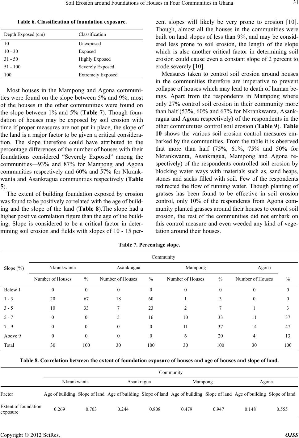 Soil Erosion around Foundations of Houses in Four Communities in Ghana 31 Table 6. Classification of foundation exposure. Depth Exposed (cm) Classification 10 Unexposed 10 - 30 Exposed 31 - 50 Highly Exposed 51 - 100 Severely Exposed 100 Extremely Exposed Most houses in the Mampong and Agona communi- ties were found on the slope between 5% and 9%, most of the houses in the other communities were found on the slope between 1% and 5% (Table 7). Though foun- dation of houses may be exposed by soil erosion with time if proper measures are not put in place, the slope of the land is a major factor to be given a critical con sidera- tion. The slope therefore could have attributed to the percentage differen ces of the nu mber of houses with th eir foundations considered “Severely Exposed” among the communities—93% and 87% for Mampong and Agona communities respectively and 60% and 57% for Nkrank- wanta and Asankragua communities respectively (Table 5). The extent of building foundation exposed by erosion was found to be positively correlated with the age of build- ing and the slope of the land (Table 8).The slope had a higher positive co rrelation figu re than the age of th e build- ing. Slope is considered to be a critical factor in deter- mining soil erosion and fields with slopes of 10 - 15 per- cent slopes will likely be very prone to erosion [10]. Though, almost all the houses in the communities were built on land slopes of less than 9%, and may be consid- ered less prone to soil erosion, the length of the slope which is also another critical factor in determining soil erosion could cause even a constant slope of 2 percent to erode severely [10]. Measures taken to control soil erosion around houses in the communities therefore are imperative to prevent collapse of houses which may lead to death of human be- ings. Apart from the respondents in Mampong where only 27% control soil erosion in their community more than half (53%, 60% and 67% for Nkrankwan ta, Asank- ragua and Agona respectively) of the respondents in the other communities control soil erosion (Table 9 ). Table 10 shows the various soil erosion control measures em- barked by the communities. From the table it is observed that more than half (75%, 61%, 75% and 50% for Nkrankwanta, Asankragua, Mampong and Agona re- spectively) of the respondents controlled soil erosion by blocking water ways with materials such as, sand heaps, stones and sacks filled with soil. Few of the respondents redirected the flow of running water. Though planting of grasses has been found to be effective in soil erosion control, only 10% of the respondents from Agona com- munity planted grasses around their houses to control soil erosion, the rest of the communities did not embark on this control measure and even weeded any kind of vege- tation around their houses. Table 7. Percentage slope. Community Nkrankwanta Asankragua Mampong Agona Slope (%) Number of Houses % Number of Houses% Number of Houses % Number of Houses% Below 1 0 0 0 0 0 0 0 0 1 - 3 20 67 18 60 1 3 0 0 3 - 5 10 33 7 23 2 7 1 3 5 - 7 0 0 5 16 10 33 11 37 7 - 9 0 0 0 0 11 37 14 47 Above 9 0 0 0 0 6 20 4 13 Total 30 100 30 100 30 100 30 100 Table 8. Correlation between the extent of foundation exposure of houses and age of houses and slope of land. Community Nkrankwanta Asankragua Mampong Agona Factor Age of buildingSlope of landAge of buildingSlope of landAge of buildingSlope of landAge of buildingSlope of land Extent of foundation exposure 0.2690.7030.2440.8080.4790.9470.1480.555 Copyright © 2012 SciRes. OJSS 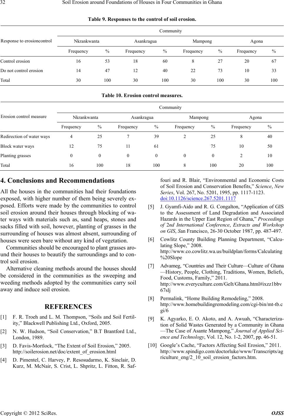 Soil Erosion around Foundations of Houses in Four Communities in Ghana 32 Table 9. Responses to the control of soil erosion. Community Nkrankwanta Asankragua Mampong Agona Response to erosioncontrol Frequency % Frequency % Frequency % Frequency % Control erosion 16 53 18 60 8 27 20 67 Do not control erosion 14 47 12 40 22 73 10 33 Total 30 100 30 100 30 100 30 100 Table 10. Erosion control measures. Community Nkrankwanta Asankragua Mampong Agona Erosion control measure Frequency % Frequency% Frequency% Frequency % Redirection of water wa ys 4 25 7 39 2 25 8 40 Block water ways 12 75 11 61 75 10 50 Planting grasses 0 0 0 0 0 0 2 10 Total 16 100 18 100 8 100 20 100 4. Conclusions and Recommendations All the houses in the communities had their foundations exposed, with higher number of them being severely ex- posed. Efforts were made by the communities to control soil erosion around their houses through blocking of wa- ter ways with materials such as, sand heaps, stones and sacks filled with soil, however, plantin g of grasses in the surrounding of houses was almost absent, surrounding of houses were seen bare without any kind of vegetation. Communities should be encouraged to plant grasses aro- und their houses to b eautify the surround ings and to con- trol soil erosion. Alternative cleaning methods around the houses should be considered in the communities as the sweeping and weeding methods adopted by the communities carry soil away and induce soil erosion. REFERENCES [1] F. R. Troeh and L. M. Thompson, “Soils and Soil Fertil- ity,” Blackwell Publishing Ltd., Oxford, 2005. [2] N. W. Hudson, “Soil Conservation,” B.T Brantford Ltd., London, 1989. [3] D. Favis-Mortlock, “The Extent of Soil Erosion,” 2005. http://soilerosion.net/doc/extent_of_erosion.html [4] D. Pimentel, C. Harvey, P. Resosudarmo, K. Sinclair, D. Kurz, M. McNair, S. Crist, L. Shpritz, L. Fitton, R. Saf- fouri and R. Blair, “Environmental and Economic Costs of Soil Erosion and Conservation Benefits,” Science, New Series, Vol. 267, No. 5201, 1995, pp. 1117-1123. doi:10.1126/science.267.5201.1117 [5] J. Gyamfi-Aido and R. G. Conga lton, “Application of GIS to the Assessment of Land Degradation and Associated Hazards in the Upper East Region of Ghana,” Proceedings of 2nd International Conference, Extracts and Workshop on GIS, San Francisco, 26-30 October 1987, pp. 487-497. [6] Cowlitz County Building Planning Department, “Calcu- lating Slope,” 2008. http://www.co.cowlitz.wa.us/buildplan/forms/Calculating %20Slope [7] Advameg, “Countries and Their Culture—Culture of Ghana —History, People, Clothing, Traditions, Women, Beliefs, Food, Customs, Family,” 2011. http://www.everyculture.com/GeIt/Ghana.html#ixzz1bbv 67slj [8] Permalink, “Home Building Remodeling,” 2008. http://www.homebuildingremodeling.com/cgi-bin/mt-tb.c gi/6 [9] K. Agyarko, E. O. Akoto, and A. Awuah, “Characteriza- tion of Solid Wastes Generated by a Community in Ghana —The Case of Asante Mampong,” Journal of Applied Sci - ence and Technology, Vol. 12, No. 1-2, 2007, pp. 46-51. [10] Google’s Cache, “Factors Affecting Soil Erosion,” 2011. http://www.spindigo.com/doctorluke/www/Transcripts/ag riculture_eng/2_10_soil_erosion_factors.htm. Copyright © 2012 SciRes. OJSS |